The 15th century seems like an unusual place to being to talk about Geography and Technology even if my
 |
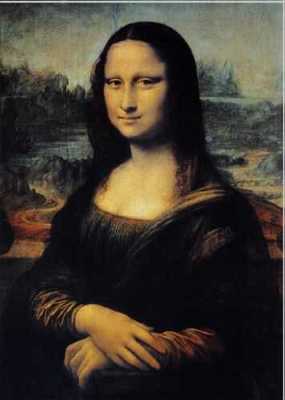
| Da Vinci |
intention is partly just to squeeze in a mention Leonardo Da Vinci. We are familiar with Da Vinci as an inventor, artist, engineer, mathematician and an undoubtedly someone who today would probably be working for Google. But perhaps not for the reason you think. Da Vinci revolutionised portrait painting and when we look at something like the Mona Lisa, it’s sometimes hard to resist the urge to move around the painting just to see whether her eyes actually do follow us. Nice though this is, the less familiar eye might miss that this painting is also one of the first attempts at painting aerial perspective. Looking at the background, our eye drawn to meandering road on its way to a lake. On the right of the painting, we can see a bridge in the distance. Leonardo used subtle colour differences to convey realistic depth and perspective to the painting.
Da Vinci went to great lengths to capture moments from nature – studies – which he could later use in his paintings. His study of flowing water on the Arno is a classic example of this. In this sketch, he’s not just trying to draw the water, but in fact he is trying to capture the very movement of the water – almost as close to animation as he could get.
Since the dawn of human civilization, humans have been drawn (!) to capture the world around them. From the cave paintings at Lascaux

 |
| LS Lowry |
Xanadu “In Xanadu did Kubla Khan
A stately pleasure-dome decree :
Where Alph, the sacred river, ran
Through caverns measureless to man
Down to a sunless sea. “

 |
| Earth Rise |
 It was inevitable that the pinnacle of our technology, space technology, would be used to capture, in new ways, the world we inhabit. Not all of us can go to space, but in the future, some archaeologists will dig out a PC (or a Chrome Book!) – from a cave – power it up and marvel that ancient man sought to capture his world by recreating it and calling it Google Earth. They will find photographs embedded in it from something called Panoramio – a crowd-sourced photographic record of the world as it was. They will find 360 Cities and see the National Geographic Layer, the human adaptations we added to the world as we tried to get to grips with the consequences of that adaptation. No doubt they will be grateful for the Roads layer to help them find their way back.
But there is a more serious side to this. The ‘new’ leaving Certificate syllabus took 10 years to see the light of day and in 1996 when it was begun, the internet still hadn’t arrived for the mass of people in Ireland. Geographical Information Systems was still in its infancy. The syllabus only recommended that students should know what is a GIS, not that they should learn to create one.

There is the germ of an opportunity in the new Junior Cycle to combine geography and technology; to take what you learn today and tomorrow and to bring it back to the classroom. And you should. Not only does location-based technology continue to be a growth sector in the Irish economy but even the digital games industry needs school leavers and graduates with an understanding of geography. Dublin is quickly becoming the
Digital Games Hub of Europe.
” Video games not only incorporate representations of landscapes, they are themselves a form of landscape representation that communicates ideas about how the world is and how it should be. Like traditional forms of landscape representation, video games use tricks of perspective and realistic graphics to represent real world places or to create worlds that appear to be real. Through their interactivity, video games also give their players a sense of power and control over the spatial form of the landscape. However, unlike traditional forms of landscape representation, video games offer opportunities to subjectively enter the space of the game and explore the social processes that help to produce the virtual landscape.”